




QUICK FACTS
Where is it? Barkly Tableland, Australia’s Northern Territory [-18.595019720, 135.2699610]
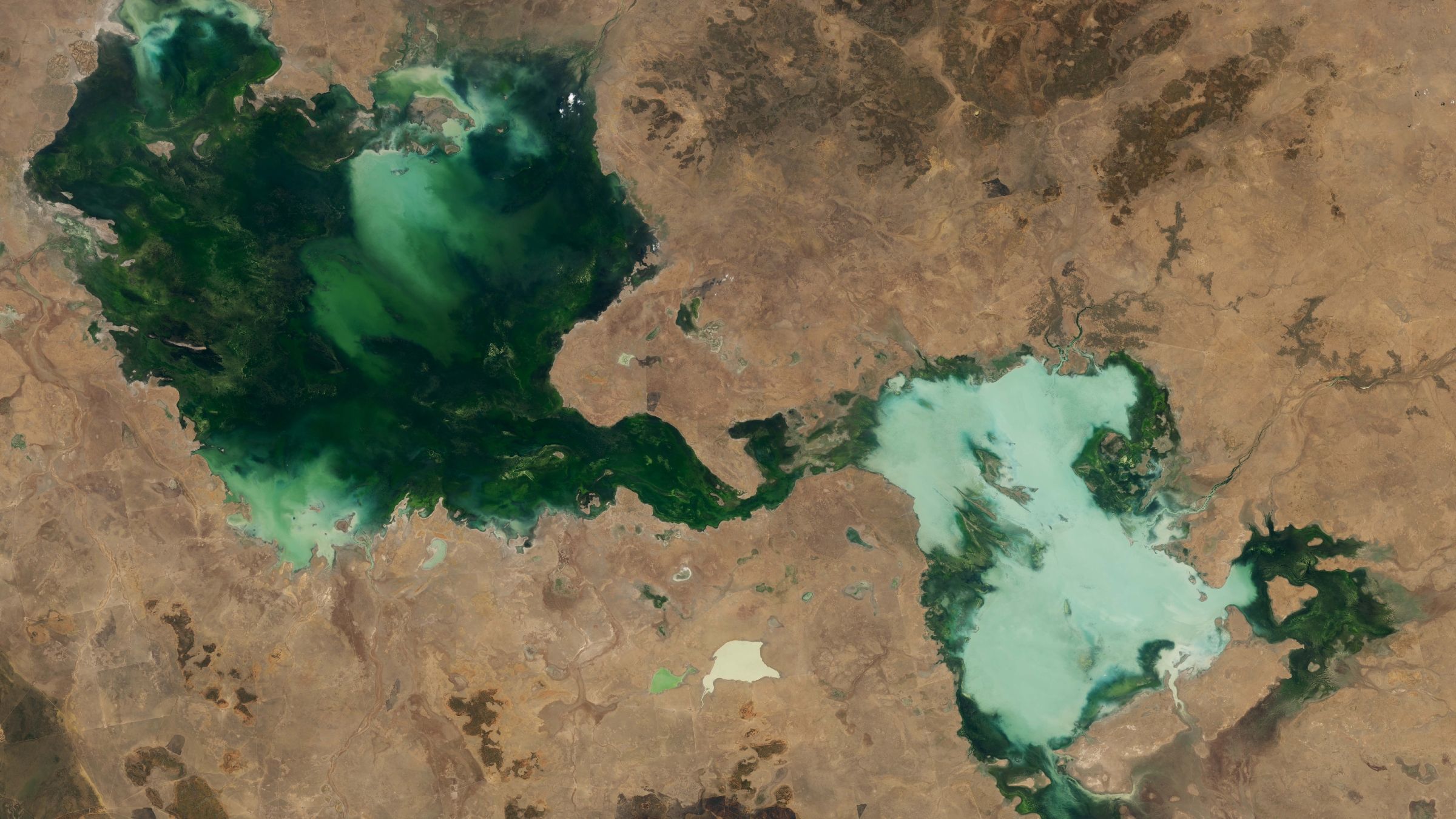
What’s in the photo? A series of ephemeral lakes that have merged into a single body of water
Which satellite took the photo? Landsat 8
When was it taken? Oct. 30, 2024
This striking satellite snap shows a series of ghostly green lakes that merged into a single murky entity after several years of unusual weather in the Australian outback.
The entwined lakes are located in Barkly Tableland, an area within Australia’s Northern Territory, which lies between the states of Queensland, South Australia and Western Australia. The largest section of the conglomerate is Tarrabool Lake (on the left side of the photo), which stretches around 55 miles (90 kilometers) across at its widest point. It is dark green due to the dense vegetation and algae in the water.
The smaller half of the merged lakes (on the right side of the image) is made up of three lakes: Lake Sylvester, Lake Corella and Lake Deburgh. This section has a paler and chalkier hue due to high levels of suspended sediment. This is likely because the lakes have overflowed and mixed together, whipping up the dust and topsoil that once surrounded them. (Several other, smaller lakes of various sizes and shades of green can also be seen throughout the image.)
All of these lakes are ephemeral, meaning they have no constant inflow or outflow of water, much like most of Australia’s other lakes. As a result, they almost completely dry out during prolonged periods of sunny weather, as high temperatures cause the water inside them to evaporate, and then reappear as heavy rainfall refills the basins.
However, across the two years prior to this image, there was so much rain that the lakes never dried out. Instead, they continued to grow year over year, as you can see from additional satellite imagery (see below), which shows the same area between 2022 and 2024.
Additional satellite imagery shows how the lakes grew significantly between 2022 and 2024. (These images were captured by the MODIS instruments on NASA’s Aqua and Terra satellites.)
(Image credit: NASA Earth Observatory/Landsat/Terra/Aqua/MODIS)
The Northern Territory’s rainy season lasts between October and April. Both the 2022-2023 and 2023-2024 rainy seasons, which preceded the 2024 satellite photos, were ranked among the top 10 wettest since 1990, according to NASA’s Earth Observatory, which released these images.
Although this is extreme, it is not that surprising, considering that annual rainfall in the Barkly Tableland rose by around 14% between 1989 and 2018, according to a report from the Australian Bureau of Meteorology. This is likely due to the effects of human-caused climate change.
Get the world’s most fascinating discoveries delivered straight to your inbox.
On top of the general increase in rainfall, Tropical Cyclone Megan dumped a massive amount of rain on the region in March 2024. The resulting flash flooding was so great that fish were seen swimming across a nearby road, Australia’s ABC News previously reported.
In the winter, Tarrabool Lake and Lake Sylvester are important breeding sites for birds, including the straw-necked ibis (Threskiornis spinicollis) and the Australian pelican (Pelecanus conspicillatus), and BirdLife International lists both lakes as important bird areas. At its fullest, Tarrabool Lake also floods the surrounding Eva Downs Swamp system, creating Australia’s largest wooded swamp.

A 2020 astronaut photo shows a massive, milky-green vortex in Lake Skadar, which lies on the border between Montenegro and Albania.

A 2024 astronaut photo shows the icy surface of Pangong Lake breaking apart in the lofty Tibetan Plateau, along a disputed border between China and India.

A 2023 astronaut photo captured a “sunglint” illuminating one of the Solomon Islands. The rare phenomenon transformed the Pacific’s largest lake into a shining silver “lens.”
TOPICS